YEAR PUBLISHED: 1799
Cote Nord-Ouest de l'Amerique Reconnue par le Cape. Vancouver. IVe. Partie
DESCRIPTION
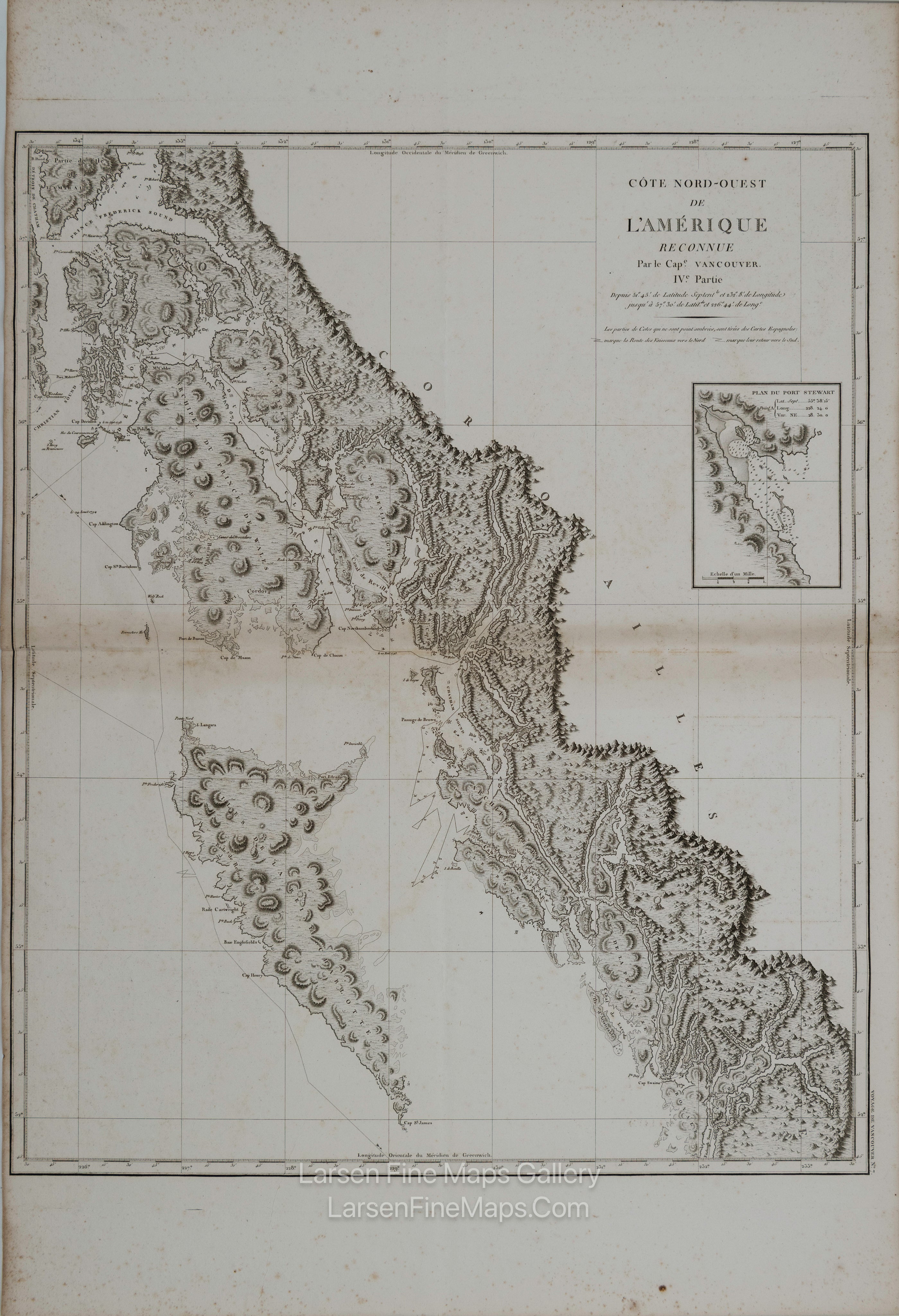
Vancouver, Cote Nord-Ouest de l'Amerique Reconnue par le Cape. Vancouver. IVe. Partie..., from Vancouver's Voyages (French Edition), 1799 (circa). Black & White. This is the French edition of a significant, large-scale chart presenting the coastal topography from Frederick Sound, Alaska, south to the Queen Charlotte Islands and east to mainland British Columbia. The track of Vancouver's route is shown zigzagging throughout the region and is coupled with excellent detail of the coastlines, along with numerous shoals, soundings, and anchorages identified. The chart features an inset of Fort Stewart on the right. During the summers of 1792-94, George Vancouver and the crew of the British naval ships Discovery and Chatham mapped the western coast of North America from Baja California to Alaska. Vancouver's voyage was the last and longest of the great Pacific voyages of the late eighteenth century. Taking the art and technique of distant voyaging to a new level, Vancouver eliminated the possibility of a Northwest Passage, and his exact surveys completed the outline of the Pacific.
This particular example of Vancouver's map was issued as plate no. 7 in the highly desirable 1799 French edition of Vancouver's Atlas. It was drawn by Lieutenant Edward Roberts and engraved by Blondeau. The rare and coveted French edition of Vancouver's Atlas is more beautifully produced, with better engraving, higher-quality paper, and more detail than the 1798 English edition. This scarce map is a core piece for any serious collection focusing on California, Vancouver, British Columbia, or the Pacific Northwest.
FULL TITLE
MAPMAKER/CARTOGRAPHER/AUTHOR
PUBLISHER
PUBLICATION
DIMENSIONS (Inches)
CONDITION
Choose options
DESCRIPTION
FULL TITLE
MAPMAKER/CARTOGRAPHER/AUTHOR
PUBLISHER
PUBLICATION
DIMENSIONS (Inches)
CONDITION
DESCRIPTION
FULL TITLE
MAPMAKER/CARTOGRAPHER/AUTHOR
PUBLISHER
PUBLICATION
DIMENSIONS (Inches)
CONDITION