YEAR PUBLISHED: 1646
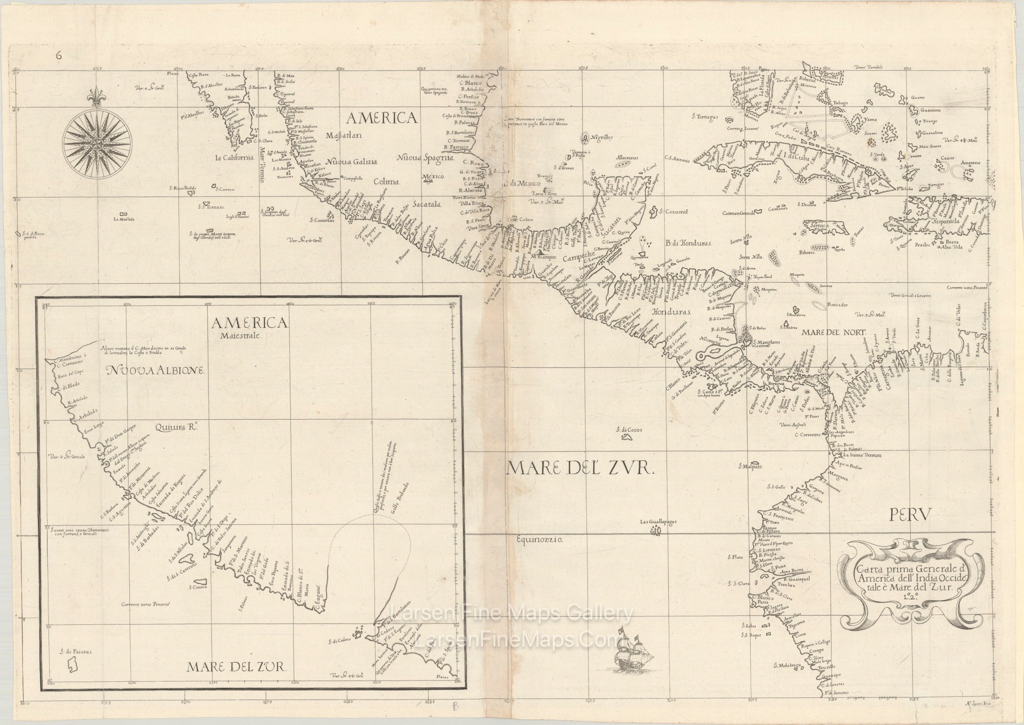
Carta Prima Generale d'America dell' India Occidentale e Mare del Zur
DESCRIPTION
The First Published Chart of The California Coast - 1646, Sir Robert Dudley
This example is actually an unknown state as far as I can determine. It falls between the 2 known states as described by Burden 266. This chart has the “6” in the upper left margin that indicates the first state of the chart, but it also has the first/top portion (“Lº.2º”) of the “Lº.2º.XV” in the title cartouche that indicates the second state of the chart. So, this appears to be state 1.5.
This rare and important chart is the first printed sea chart of the California coast. It was based upon Sebastian Vizcaino’s voyage in 1602 to find suitable ports for Spanish Galleons returning from the Philippines. The chart was one of two general charts of North America in Dudley’s sea atlas, covering a wide geographic area from the southern tip of Florida west to Baja California and south to Central America and northern South America. Of particular interest is the inset map America Maiestrale which extends the main map north to C Mendocino, which is placed too far north. This inset locates Po: di S: Diego, Encieada di S: Andreas di Buena Gure (San Pedro Bay), Costa Sicura Le Gente Sono Grande (Santa Barbara), and three anchorages located by Vizcaino. Dudley has represented California as a peninsular here, but has left open the possibility that it is an island with a large speculative Golfo Profondo jutting to the north. The chart is elegantly engraved with fine calligraphy, a bold title cartouche, sailing ship and compass rose by the Florentine craftsman Arnoldo Lucini. This is the first state with number 6 at top left.
Robert Dudley was the first Englishman to produce a sea atlas, Dell Arcano del Mare (Secrets of the Sea). Dudley, a skilled mathematician and navigator, was exiled from England and settled in Florence where his atlas was published. He introduced a totally new style for sea charts in the atlas with only lines of latitude and longitude and no rhumb lines. The charts were meticulously compiled from original sources and were both scientific and accurate for the time. This important atlas was the first sea atlas of the whole world; the first to use Mercator's projection throughout; the earliest to show the prevailing winds, currents and magnetic deviation; and the first to expound the advantages of Great Circle Sailing. In an introductory leaf found in one copy in the British Library, the engraver (Lucini) states that he worked on the plates in seclusion for twelve years in an obscure Tuscan village, using no less than 5,000 pounds of copper for the printing plates. It was only issued in two editions and the maps are rarely seen on the market. This map is from the first edition.
References: Burden #266; Shirley (BL Atlases) M.DUD-1a #3.
On watermarked paper with light toning along the centerfold and some small abrasions along the upper centerfold. A 3" centerfold separation at top and a couple of edge tears confined to the bottom blank margin have been closed on verso with archival materials.
FULL TITLE
MAPMAKER/CARTOGRAPHER/AUTHOR
PUBLISHER
PUBLICATION
DIMENSIONS (Inches)
CONDITION
Choose options
DESCRIPTION
FULL TITLE
MAPMAKER/CARTOGRAPHER/AUTHOR
PUBLISHER
PUBLICATION
DIMENSIONS (Inches)
CONDITION
DESCRIPTION
FULL TITLE
MAPMAKER/CARTOGRAPHER/AUTHOR
PUBLISHER
PUBLICATION
DIMENSIONS (Inches)
CONDITION