YEAR PUBLISHED: 1863
Boston Harbor Massachusetts
DESCRIPTION
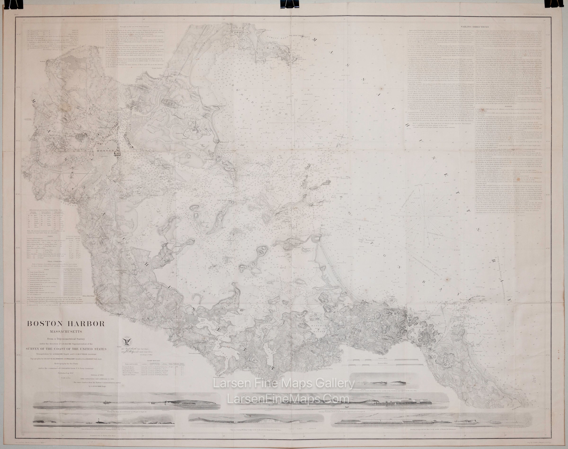
This is a very highly detailed chart of Boston Harbor, Massachusetts. This chart shows incredible and significantly more inland and coastal detail than almost all other Coast Survey charts. Starting at Scituate Harbor to the SE of Massachusetts Bay, up into Boston Bay and Broad Bay, and ending at Nahant Bay and Lynn Harbor in the north. The chart shows detailed roads, towns, cities, buildings, property/farm boundaries, topographical features (hachures and shading), lakes, ponds, rivers, piers, railroads, lighthouses, etc. Extensive depth soundings, bathymetric shading, aids and hazards to navigation, buoys, beacons, ranges, bearings, rocks, islands, shoals, landings, channels, bottom conditions, etc, show the coastal details. Lengthy notes provide sailing directions and dangers to the mariner. Tidal information is also given, including currents, lighthouse details, and other remarks. Along the bottom are seven elevation views showing the land from various approaches. Some towns and cities shown in detail are Boston, Cambridge, Charlestown, Roxbury, Dorchester, Medford, Milton Mill's Village, Quiney Village, Old Spain, and Hingham. This is the revised edition of the 1863 chart from the original 1857 publication.
Rare heavy paper, thick paper issue.
FULL TITLE
MAPMAKER/CARTOGRAPHER/AUTHOR
PUBLISHER
PUBLICATION
DIMENSIONS (Inches)
CONDITION
Choose options
DESCRIPTION
FULL TITLE
MAPMAKER/CARTOGRAPHER/AUTHOR
PUBLISHER
PUBLICATION
DIMENSIONS (Inches)
CONDITION
DESCRIPTION
FULL TITLE
MAPMAKER/CARTOGRAPHER/AUTHOR
PUBLISHER
PUBLICATION
DIMENSIONS (Inches)
CONDITION