
YEAR PUBLISHED:1937
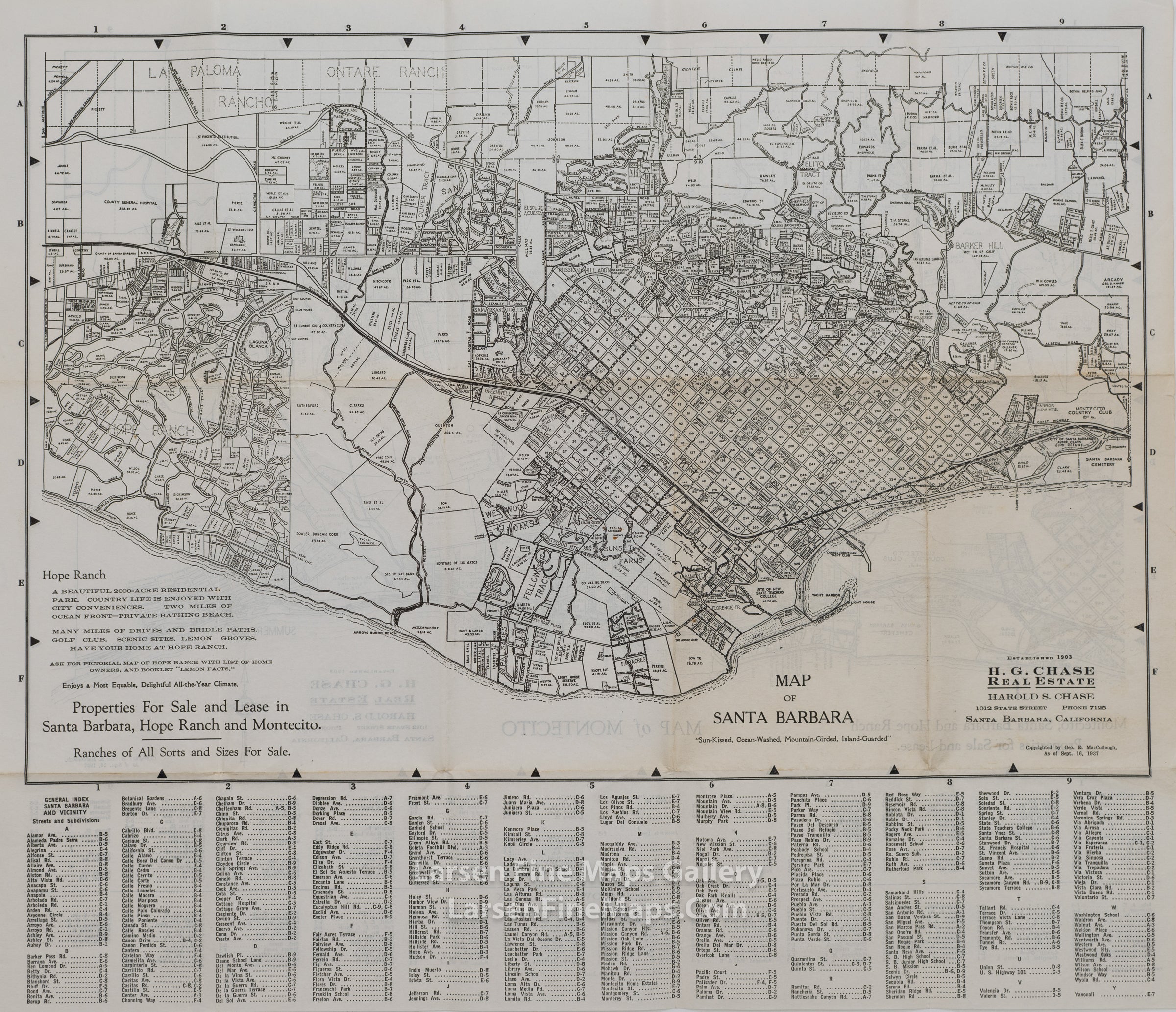
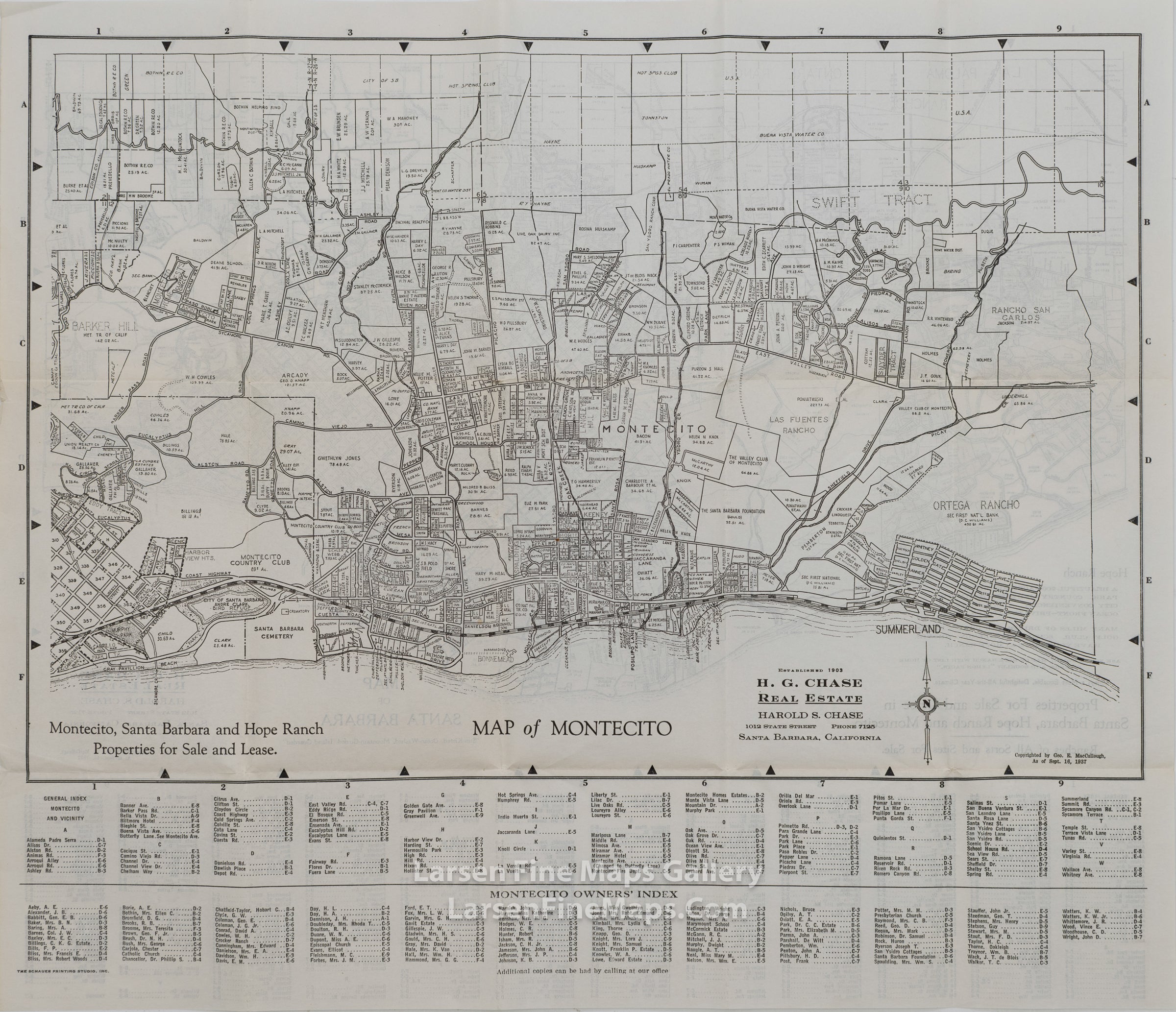
Map of Santa Barbara Map of Montecito
DESCRIPTION
[Santa Barbara] H. G. Chase, Real Estate. Map of Santa Barbara, ''Sun-Kissed,· Ocean-Washed, Mountain-Girded, Island-Guarded." [Santa Barbara, CA: Harold S. Chase, 1937. Broadsheet. 17 x 19 1/2 inches. 6 1/2 x 4 1 /4 inches folded. [2] pp. Verso is a Map of Montecito, index of developments and streets on the recto, index of Montecito Owner's on the verso; text clean, unmarked, toning at folds, some small tears at folds, minor tears and folding at edges.
FIRST EDITION. Harold Stuart Chase (1890-1970) was born in Suffolk, Massachusetts. It is unclear to me when he arrived in Santa Barbara, CA, but this map indicates that H. G. Chase Real Estate was established in 1903. Harold Stuart Chase was responsible for the development of Hope Ranch. In 1925, Chase organized a syndicate known as La Cumbre Estates Corporation that purchased the 1,200 acres situated west of Las Palmas and Roble Drives and 'the agricultural land located south of Hollister Avenue. The La Cumbre Estates Corporation developed the land into the residential area that exists today. The first houses constructed were 'Las Terrasas' built in 1925 as the home of Harold S. Chase and 'Florestal' built in 1926 for Peter Cooper Bryce." Wikipedia. This map, published in 1937, was one of several maps issued by Harold S. Chase Real Estate as early as 1929, in support of Chase's real estate business. REFERENCES: Kruska and Robinson record 4 H. G. Chase maps of Santa Barbara and / or Hope Ranch in A Collection of Santa Barbara, San Luis Obispo, and Ventura Pamphlets & Ephemera, Nos. 412-415. OCLC records 12 maps from 1913 to 1950, but some are maps of Hope Ranch or other specialized maps.
FIRST EDITION. Harold Stuart Chase (1890-1970) was born in Suffolk, Massachusetts. It is unclear to me when he arrived in Santa Barbara, CA, but this map indicates that H. G. Chase Real Estate was established in 1903. Harold Stuart Chase was responsible for the development of Hope Ranch. In 1925, Chase organized a syndicate known as La Cumbre Estates Corporation that purchased the 1,200 acres situated west of Las Palmas and Roble Drives and 'the agricultural land located south of Hollister Avenue. The La Cumbre Estates Corporation developed the land into the residential area that exists today. The first houses constructed were 'Las Terrasas' built in 1925 as the home of Harold S. Chase and 'Florestal' built in 1926 for Peter Cooper Bryce." Wikipedia. This map, published in 1937, was one of several maps issued by Harold S. Chase Real Estate as early as 1929, in support of Chase's real estate business. REFERENCES: Kruska and Robinson record 4 H. G. Chase maps of Santa Barbara and / or Hope Ranch in A Collection of Santa Barbara, San Luis Obispo, and Ventura Pamphlets & Ephemera, Nos. 412-415. OCLC records 12 maps from 1913 to 1950, but some are maps of Hope Ranch or other specialized maps.
FULL TITLE
MAPMAKER/CARTOGRAPHER/AUTHOR
PUBLISHER
PUBLICATION
DIMENSIONS (Inches)
CONDITION
Choose options
DESCRIPTION
FULL TITLE
MAPMAKER/CARTOGRAPHER/AUTHOR
PUBLISHER
PUBLICATION
DIMENSIONS (Inches)
CONDITION
DESCRIPTION
FULL TITLE
MAPMAKER/CARTOGRAPHER/AUTHOR
PUBLISHER
PUBLICATION
DIMENSIONS (Inches)
CONDITION