YEAR PUBLISHED: 1852
Reconnaissance of the Western Coast of US, San Francisco to San Diego
DESCRIPTION
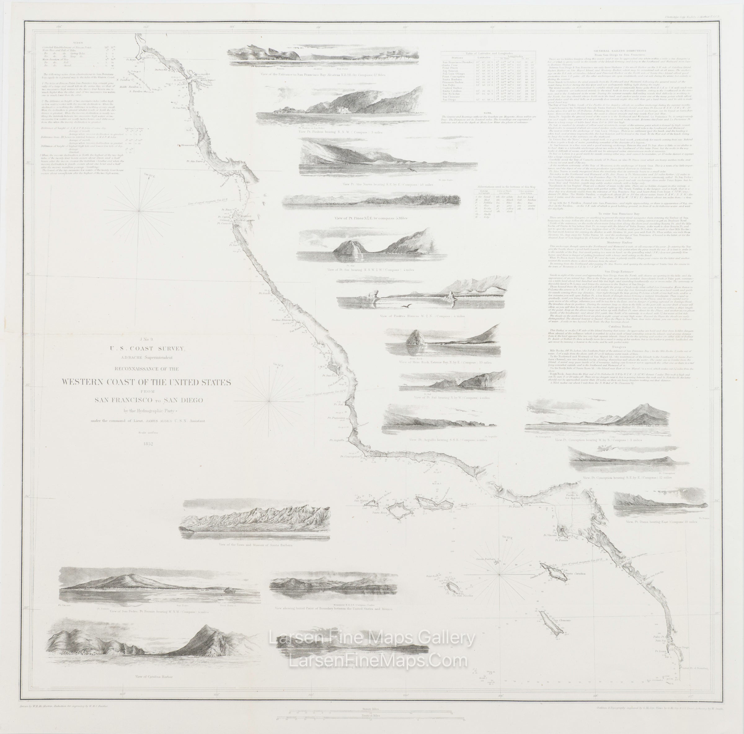
A gorgeous chart of the Pacific coast from Pt. Reyes just north of San Francisco, California south to the San Diego area and the border with Mexico. This is one of the most desirable U.S. Coast Survey charts and the most sought-after. This chart's most beautiful and dramatic quality are the 17 elevation views of various locations and ports along the coast.
The elevation views from north to south are:
'View of the Entrance to San Francisco Bay,' 'View Pt. Piedras,' 'View Pt. Ano Nuevo,' 'View of Pt. Pinos,' 'View of Pt. Sur,' 'View of Piedras Blancas,' 'View of Moro Rock,' 'Esteros Bay,' 'View of Pt. Sal,' ' View Pt. Arguila,' 'View Pt. Concepcion bearing W. by S.,' 'View of Pt. Concepcion bearing S.E. by E.,' 'View Pt. Duma,' 'View of the Town and Mission of Santa Barbara,' 'View of San Pedro, Pt. Fermin,' 'View showing initial point of boundary between the United States and Mexico,' 'View of Catalina Harbor,' and a 'View Pt. Loma.'
The chart includes many place names and points along the coast and inland, such as; El Pueblo de Los Angeles, the Chanel Islands, San Diego Bay, the Los Angeles Plain, the Mission of San Fernando and the San Fernando Valley, and the San Francisco Bay area including the City of San Francisco, Oakland, San Jose, Union City and Alviso.
Also included on the map are depth soundings, three compass roses, sailing directions from San Francisco to San Diego, and into various ports and harbors, tidal notes, anchorages, dangers, and other information.
IMPORTANT NOTE:
All of our United States Coast Survey (USCS), United States Coast & Geodetic Survey (USC&GS), and similar maps and charts have been professionally unfolded and flattened using humidity baths, semi-permeable membrane, and drying blotter techniques. Most others you typically see on eBay have not been, and worse, are quickly and crudely unfolded for the low-quality photos you see. Unfolding these maps in that way is damaging and weakens them. Please be aware.
FULL TITLE
MAPMAKER/CARTOGRAPHER/AUTHOR
PUBLISHER
PUBLICATION
DIMENSIONS (Inches)
CONDITION
Choose options
DESCRIPTION
FULL TITLE
MAPMAKER/CARTOGRAPHER/AUTHOR
PUBLISHER
PUBLICATION
DIMENSIONS (Inches)
CONDITION
DESCRIPTION
FULL TITLE
MAPMAKER/CARTOGRAPHER/AUTHOR
PUBLISHER
PUBLICATION
DIMENSIONS (Inches)
CONDITION