
YEAR PUBLISHED: 1857
Pictorial Map of The United States, 1857
DESCRIPTION
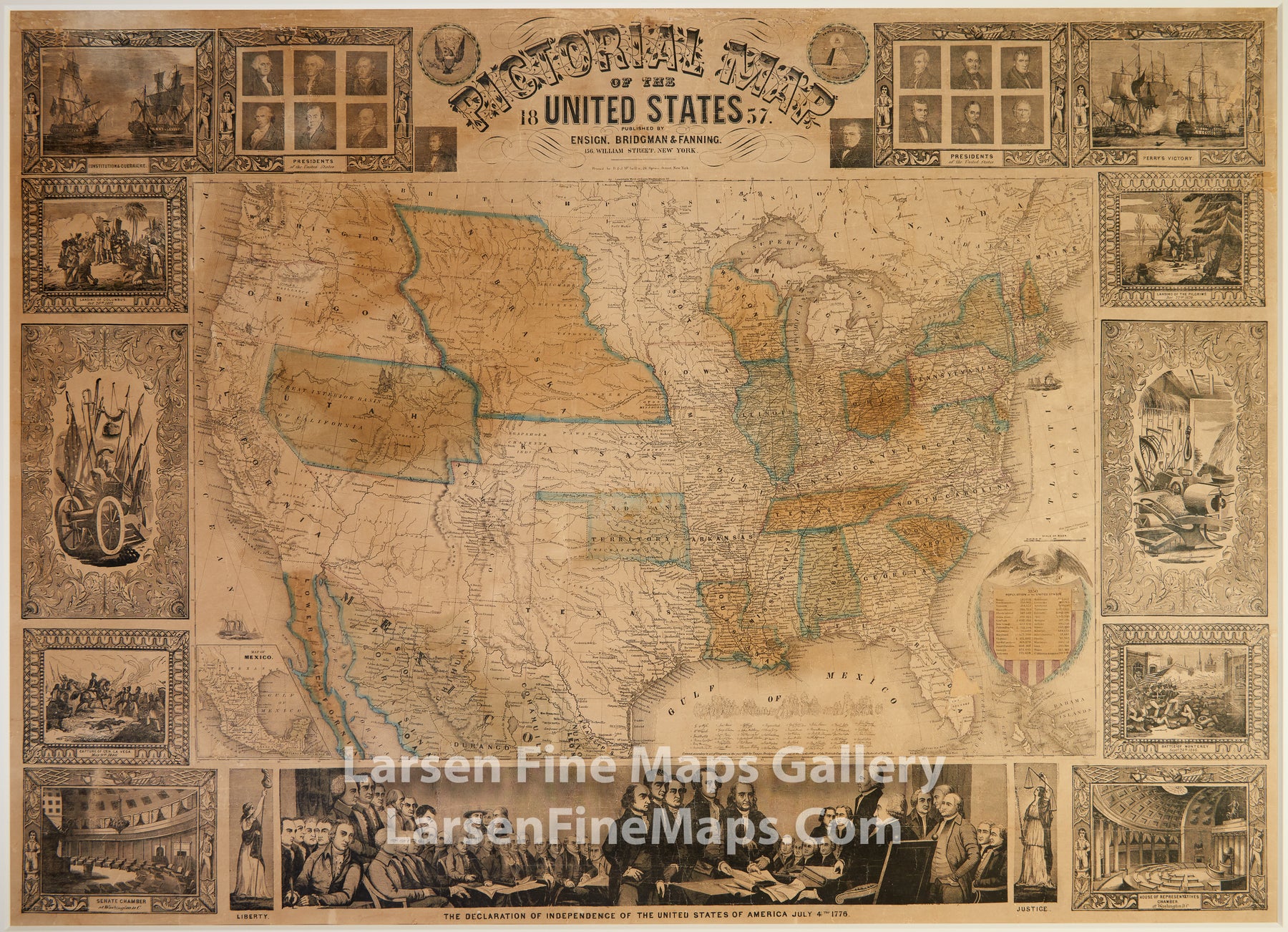
A decorative wall map of the United States. Shows the "Gold Region" in California. Includes numerous decorative pictorial vignettes illustrating historical events and persons.
1) USS Constitution vs HMS Guerriere during War of 1812.
2) Presidents of The United States (Washington, John Adams, Jefferson, Madison, Monroe, J.Q. Adams, Pierce).
3) Presidents of The United States (Jackson, Van Buren, Harrison, Polk, Tyler, Taylor, Fillmore).
4) Perry's Victory at the Battle of Lake Erie between British and American forces during the War of 1812.
5) Landing of The Pilgrims, December 22nd, 1620.
6) Farming tools.
7) Battle of Monterey, September 24th 1846. General Pedro de Ampudia and the Mexican Army of the North were defeated by the Army of Occupation under the command of Zachary Taylor.
8) House of Representatives Chamber at Washington D.C.
9) Justice.
10) The Declaration of Independence of The United States of America, July 4th 1776.
11) Liberty.
12) Senate Chamber at Washington D.C.
13) Capture of General La Vega, May 9th 1846. At the Battle of Resaca de la Palma during the Mexican-American War, General Zachary Taylor engaged the retreating forces of the Mexican Army of The North, capturing General La Vega and driving the Mexicans out of Texas.
14) Cannon and war implements.
15) Landing of Columbus, October 20th, 1492.
This map has been extensively and professionally restored and preserved. It has a professional white matting, protective backing (NOT adhered) and museum quality plexiglass protective covering. Original ebonized wood rollers included but separate from map.
Treatment Steps:
1 Remove scroll bars mechanically.
2 Dry clean verso of map using dry sponge eraser to reduce heavy layer of surface dirt.
3 Mechanically reduce insect residue.
4 Duct tapes on verso will be mechanically removed with heat and/or organic solvents.
5 Reduce adhesive residue from duct tape mechanically and using heat and/or organic solvents.
6 Remove 3" of pressure sensitive tapes and adhesive residue mechanically, with heat and/or using organic solvents. 7 Mechanically reduce varnish layer overall using alcohol solution.
8 Water wash in filtered water to reduce soluble stains.
9 Fill losses and repair tears by lining overall to Japanese tissue using wheat starch paste.
10 Fill losses using matching liquid paper pulp.
11 Humidify and flatten overall between wool felts.
12 Inpaint losses using colored pencil. No large design losses will be recreated, just toned to match surrounding area.
Museum Quality Preservation:
1 Map placed into a plexi package for travel, storage or for future framing.
Gallery site has Hi-Res Images available.
FULL TITLE
MAPMAKER/CARTOGRAPHER/AUTHOR
PUBLISHER
PUBLICATION
DIMENSIONS (Inches)
CONDITION